

To show a location most people would probably turn to Google Maps to “drop a pin”. However, Google Maps is about the human world and has little or no detail for places of nature like Oakley Wood. Instead, we can use OpenStreetMap, which does. The Friends originally mapped the Oakley Wood features for OpenStreetMap and we use it for all our maps.
By the way, the name “OpenStreetMap” is quite misleading as it doesn’t focus on streets any more than any other map feature. “OpenWorldMap” might be appropriate although this name exists for something else – a map which ironically is based on OpenStreetMap. In fact, most of the free-to-use mapping you come across is based on OpenStreetMap data.
So, using your mobile phone, go to www.openstreetmap.org and find Oakley Wood, or use the following link to get there directly:
https://www.openstreetmap.org/
Tap the “share” icon on the right-hand side (the 3 dots connected by 2 lines) and then tap “Include marker” in the Share panel that appears. This causes a blue marker to appear over the map. Move the map around (the map moves under the marker) and when the marker is over the place you want to identify, tap “Link”. The address underneath is now a link that refers to the marker location.
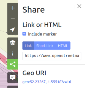
To use it, long press on the link address. Tap “Select all” and then “copy” to get the address on the clipboard. Then paste it to wherever you want, Facebook, WhatsApp, an email, etc. To paste the link, typically you long press where you want it and tap “paste”.