
(Some of the information in here is taken from a survey conducted by the Friends of Oakley Wood in 2021 and supplied to Historic England and the Warwick Historic Environment Record.)
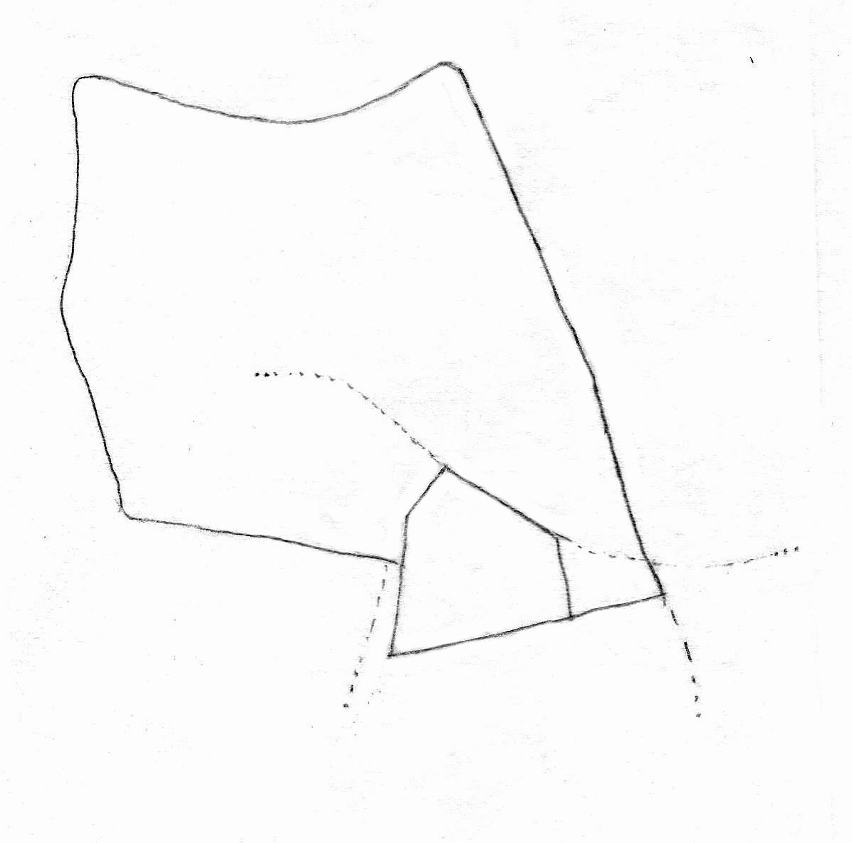
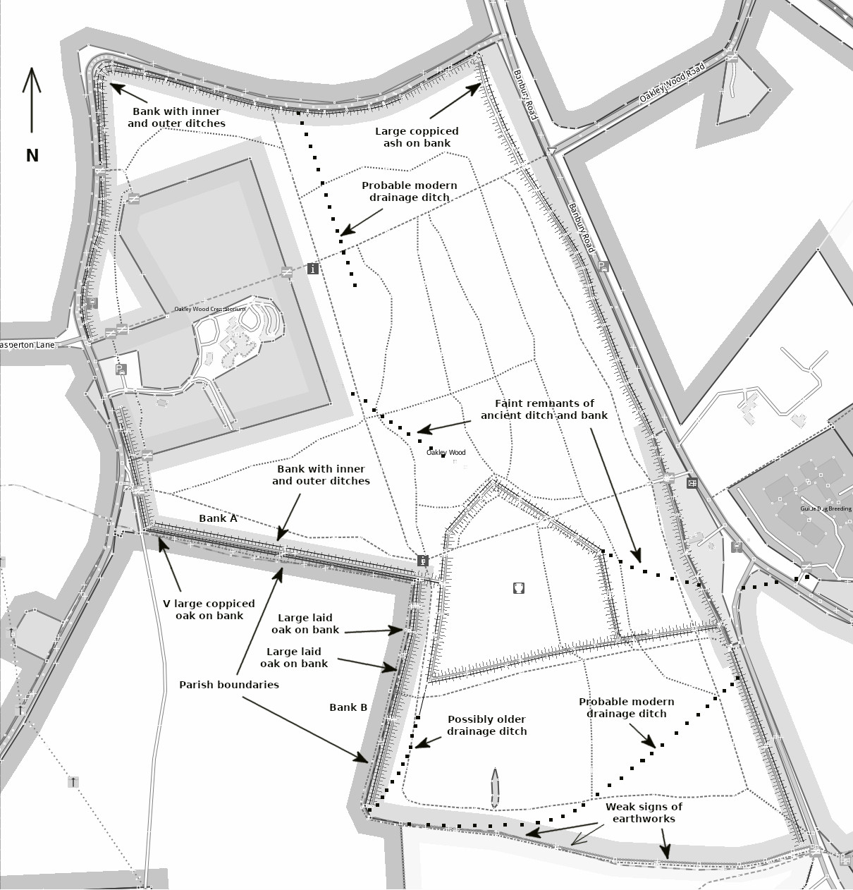
Oakley Wood has two obvious earthwork features: inner ones identified as the “camp”, and banks and ditches that surround most of the wood. These are identified in three separate Warwick HER records. The camp itself is described in two separate records (HER attempts to be agnostic regarding its nature): MWA715 that describes it as a hillfort, and MWA6201 that views it as a “Possible Medieval Woodland Boundary”. The third, MWA13162 describes the woodbanks that bound the perimeter of the wood.
(Note MWA6201 shows the wrong location, and there are other updates to these records that may not be online yet – Feb 2021.)
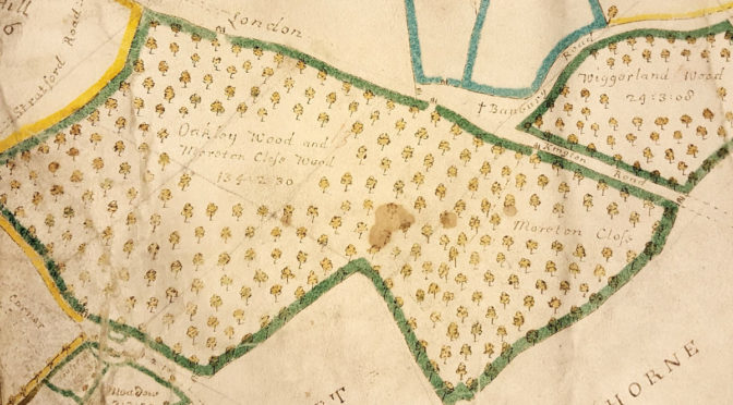
Despite the widely accepted belief that these features are medieval or earlier in origin, there is surprisingly no documented evidence of them that is much older than 100 years. The 1885 OS map of Oakley Wood shows the boundary banks (around the northern part of the wood only), and the camp as an ancient site. Earlier maps of the wood from 1835, 1803 and 1710 do not show the camp or any earthworks.
The earliest reference in the HER record for the camp is to be found in “The Victoria History of The County of Warwick, Vol 1” published in 1904. It shows a map of Oakley Wood described as “about AD 1875, after Burgess” and has a detailed description of the camp. It is described as a fort, and adds “Local antiquaries have invariably described these remains as Roman, without apparently any kind of proof of the assertion. No antiquities of any kind are known to have been dug up here, to afford a clue either to the occupiers or the makers of the earthworks. As far as mere outward appearances go, the stronghold more or less resembles some of the works of class BII(*), but the site requires exploration with the spade before any definite opinion to age or origin can safely be expressed.”
(* I’ve no idea what this means – Chris)
Later entries in these records for the camp offer no evidence of age or origin, only opinion. Earlier theories all refer to the earthworks as a hillfort, but in 1986 Richard Hingley, for the Warwickshire Museum, suggested a “medieval and post-medieval woodland management” explanation, again recommending that excavation would be needed to resolve the question. There is no record that any such excavation has ever been carried out.
The HER record for the outer earthworks, or woodbanks, contains only one entry, a survey conducted by John Brace (ref.3) for the Warwickshire Museum in 2010. It provides a survey and report on the banks around Oakley Wood and the adjacent Wiggerland Wood.
History and purpose of the Earthworks
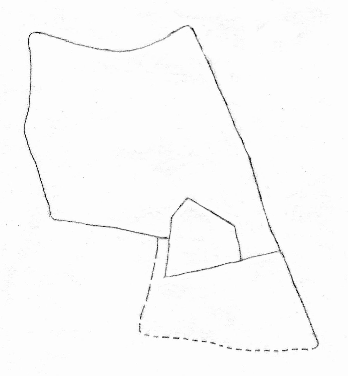
The history of the earthworks is unknown. As already mentioned, there are no documented records of any of them before 1875. Although the origin of the inner earthworks (the “camp”) is disputed, there appears to be no dispute that the outer earthworks are woodbanks, which were typically created during medieval inclosure.
The Outer Earthworks
There is no doubt that Oakley Wood itself is old, documented references to it date back to the 11th century, and it is variously called Acle, Ocle, Oklie, Okeley, Okely, before its modern name became settled in the 19th century. The woodbanks are never mentioned though, possibly because woodbank boundaries were ubiquitous and not worth remarking on. The documented inclosure of the wood around 1300 (ref.2) is reasonably assumed to be when the boundary woodbanks were created – but not proven.
The OS map of 1885 shows woodbanks only around the northern half of the wood at that time. These abut the inner earthworks and incorporate them as part of what would have then been the southern boundary of the medieval inclosure. The ditch and banks that bound at least some of the southern half of the wood are noticeably different, being lesser and in some places non-existent. More about these later.
The Inner Earthworks
The existence of the inner earthworks (the “camp”) is not actually documented before the 19th century although it is widely accepted that they date from at least medieval times, and the way they interlink with the outer earthworks suggests they already existed at the time of inclosure.
There appears to be little to support the idea that the inner earthworks represent an historic fortification. The following observations have already been made by various qualified commentators:
- It is not in a particularly elevated or strategically useful situation for a hillfort.
- There is no obvious, defensible entrance typical of a hillfort.
- It has an atypical shape for a hillfort.
Apart from a part of the NE section, the dimensions of the earthworks are similar to the outer woodbanks, providing little reason to suppose these have a different purpose.
Oliver Rackham, acknowledged expert on the subject of ancient woodlands (see ref.1 and other books), made observations about woodbanks that are relevant here:
- where a wood has increased in size, the old boundary nearly always survives as an internal earthwork.
- where a bank turns a sharp corner there is a corner mound formed by the earth thrown up from both sides of the ditch. This is true of the camp.
- There is at least one example of earthworks of a similar shape and enclosed area that are recognised woodland boundary banks (Knapwell Wood, Cambridgeshire)
These points add up to being a strong argument for these inner earthworks being earlier woodbanks.
Oakley Wood, Moreton Close and Wigland Wood
The map of 1710 shows that the southern part of what is now Oakley Wood was called Moreton Close, although no other map, earlier or later, mentions this name. Maps of 1787 and 1835 name it Wigland Wood (the same name given to the wood on the other side of the Moreton Morrell Road, now called Wiggerland Wood). This lower part of the wood may have been known by different names; however, what is important is that until relatively recently it is shown as being not part of Oakley Wood. This supports the belief that at the assumed time of the inclosure of Oakley Wood in C1300 this southern part was a separate wood and not included.
This separation would explain why the boundary woodbanks shown in the 1885 OS map enclose only the northern part of Oakley Wood; there are no woodbanks shown to the south, and the modern OS map continues to show none (but see Note 1). It is clear that the nature of the boundary banks and ditches in this southern part is different; whereas the those in the northern part are relatively uniform in size all around the boundary, in the southern part they are not:
- to the E side, alongside the Moreton Morrell road, they are fairly uniform and of similar width to those in the northern part but slightly less deep or high
- to the S, alongside the meadow, they are mostly non-existent
- to the W, alongside the cultivated field, they are generally lesser, but have many old, coppiced trees growing on or in them.
This latter boundary, together with the N side of the same field, forms the parish boundary between Bishops Tachbrook (Warwick) and Newbold Pacey (Stratford-on-Avon) and these old coppiced trees suggest they are the remains of an ancient boundary hedge between the two.
The varied nature of the ditches and banks of the southern part suggest they are not part of an inclosure, but perhaps constructions from different times with different purposes.
Other Earthworks
The survey uncovered the remnants of other ditches and banks in addition to those commonly known, and that are largely overgrown. Most are likely to be those referred to by John Brace in his report as relatively modern drainage ditches. However, one is particularly interesting as it could well predate all other earthworks, including the camp.
The faint remnants of this bank and ditch leads SE from the NE apex of the camp towards the boundary of the wood, and another NW from the N apex towards the crematorium. In the SE it continues across the corner of Wiggerland Wood and is still visible for a short distance on the other side of the B4100. To the NW, the bank and more obviously the ditch continue into the crematorium grounds. They may have continued further but the construction of crematorium and more lately the car park will have destroyed any traces.
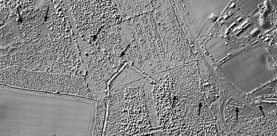
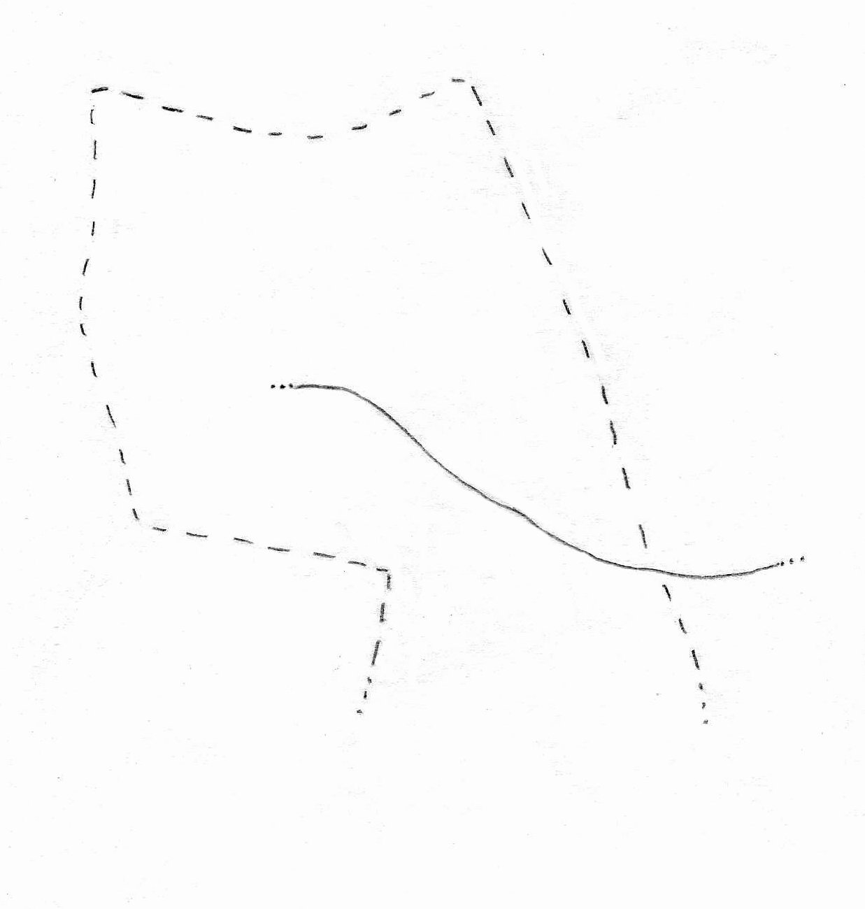
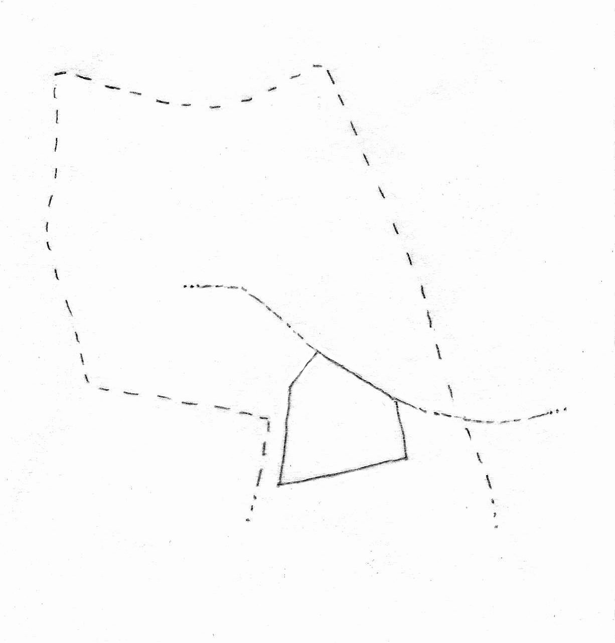
Where the SE bank meets the camp, the ditch of the eastern side of the camp where it turns S appears to cut across it (a diagram in the survey details this), suggesting that this faint ditch is older. More intriguingly, a continuous NW-SE line is formed by the two ditches (and the side of the camp) as if they are part of the same feature. And if they are indeed older, then it is possible, perhaps even probable, that when the camp was constructed this old ditch and bank was incorporated as the NE side. The remnants of these ditches and banks are now difficult to find on the ground as they much is hidden under the brash from the recent felling work.
An interpretation of this feature is that it formed an ancient continuous ditch and bank that predate the camp, and was incorporated as the NE side of the camp when it was constructed. This ancient ditch and bank would appear to predate the roads.
Possible Timeline of the Earthworks
This sequence of events is speculation, partly deduced from the way the earthworks interact.
1. Ancient ditch and bank constructed
Age and purpose unknown, They would appear to predate the camp and the roads.
2. The inner earthworks are constructed, incorporating the ancient ditch and bank on NE side
The “camp” is a small enclosure, probably boundary banks. Age unknown.
3. The northern part of Oakley Wood is enclosed with woodbanks
The existing inner earthworks are incorporated as part of the new wood boundary. The date is likely to be C1300 but there is no certainty. The woodbank that runs to the W from the camp towards the Wellesbourne Road has many old and large coppiced trees, consistent with having been a laid hedge at some time in the past, probably some centuries ago.
4. Lesser woodbanks are constructed in the south of the wood
The boundary around this part of the wood is varied, probably created at different times and so doesn’t constitute an inclosure as such. The west side that bounds the field has a number of obviously old coppiced trees typical of an aged laid hedge. It may be that it is part of an ancient boundary of Moreton Wood, making it really quite old.
The present day
There are ditches without banks in three places in the wood. John Brace believed them to be recent, probably an attempt to improve drainage as part of the post-WW2 replanting. They are consistent with the topology of the land, which falls away to the NW and SW. On some old maps a pond is shown in the far NW corner, adjacent to the road.
The short SW ditch is less distinct than the other two so it may be older and possibly connected with the inner earthworks. It is still noticeable as a dip in the path it crosses.
Inevitably some of these features are gradually becoming lost as maintenance activity in the wood continues. As a Scheduled Monument, the camp is protected by law, and WWT who manage the forestry operations are respectful of the outer woodbanks and try to ensure that they are not damaged by the contractors. They are probably unaware of the lesser features and so they have been ignored. But there is an important question: if the inner earthworks are actually woodbanks then arguably all the woodbanks in the wood should be viewed as equally important and afforded the same level of protection.
Note 1: I queried the OS about the absence of woodbank features in the south of the wood, and as a result they went and mapped them. They eventually replied “The wood banks at the southern end of Oakley Wood have now been surveyed. They will be visible in the October release of MasterMap (25/10/21)”. They gave no explanation why they had not been surveyed before.
References
- Oliver Rackham, The History of the Countryside and Trees and Woodland in the British Landscape.
- Sarah Wager, Woods, Wolds and Groves: the woodland of medieval Warwickshire.
- John Brace, Oakley Wood, the Camp & the wood Banks, unpublished report for the Warwickshire Museum, 2010.
- Chris Wood, Survey of Oakley Wood Camp, August 2021.
A complete LIDAR map of Oakley Wood can be viewed here. It was taken around the year 2000.